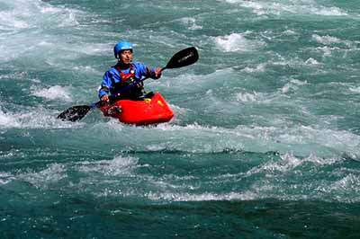
世界圣地
受到闪米特大侠成功完成泰柬海岸线鼓舞,我们美国华人水上团队正式开启, 世界最知名的海洋舟路线,INSIDE PASSAGE的筹划工作。
更巧的事,本来是2015年完成第一阶段的活动,而2014是打算实现科罗拉多河的CATARACT 峡谷漂流,由于我们头号主力也是摄影师回国结婚,我们推迟那个活动,于是把这个活动提前到今年。
这是大陆中国团队,将第一次 探索这神奇长于2000公里的海岸线。

 kurtyang04
·
2014-01-17 21:51
kurtyang04
·
2014-01-17 21:51
这2000公里至少是 70天时间才能完成, 由于没有长假,加上我又不喜欢solo,几乎没有机会个人完成这条线。于是能感受到那里的奇妙是我个人第一选择,充分利用当地资源,分而治之,每段挑选精华,做成多年的系列。
一天之内我们从全美户外朋友里,筹到六七位有实力, 几乎肯定的承诺,过去连续4年西部漂流大获成功让我们备受户外同学的信任。
kurtyang04
·
2014-01-17 22:26
‘The Inside Passage stretches 1300 miles from Puget Sound north and west, between Vancouver Island and the British Columbia mainland, continuing past Juneau to Glacier Bay in Alaska. The waters are protected from the Pacific by scattered islands, but huge expanses are teased by winds and tides that can rise swiftly, 30 feet from low water to high, creating crazy currents.’
大概(包括其他资料)说长2000公里,从西雅图到阿拉斯加的冰川公园。 潮汐落差最高达10米,非常强的激流,潮汐河流形成的浪可高达3米。流速最快达 27km/h.
整个路线是国内根本没有类似地,不说环境,植被和动物不同,潮汐影响很大,据说非常复杂,是设计的关键。
绝大部分是半公开水域或非公开水域,受涌浪的影响比较小,但风比较大。
八月最低水温 九到十度, 最高水温是十五度。
由于我们在0度的冰川河漂流过,附近的缅因潮汐河特别多,这边的水温很接近,造就了我们良好训练环境,也是信心所在。
kurtyang04
·
2014-01-17 22:50
2014的计划:
只有七天+一两天飞机轮渡, 时间非常有限。 也受器材和费用限制,我们只能围着有租船的地方转。
我们计划的区有俩块:Desolation Sound , Johnstone Strait. 前者有几个深达两千米的类似挪威海峡, 后者是世界最著名划船看鲸鱼的地方。
 kurtyang04
·
2014-01-22 18:41
kurtyang04
·
2014-01-22 18:41
巨浪是3米,潮汐 落差是10米
这最危险地方,果然出事:
kurtyang04
·
2014-01-22 18:44
Skookumchuk Narrows 激流可能是世界上最知名, 也是死人最多的潮汐河海洋激流
“Two coast guard volunteers are dead after a boat capsized Sunday morning in Skookumchuck Narrows, near Sechelt on B.C.'s Sunshine Coast.
Capt. Annie Djiosta, a public affairs officer with the Royal Canadian Navy in Esquimalt, said a rigid hull inflatable boat with four people on board capsized at about 11:30 a.m. PT.
"Of the four people on board … the boat, two were rescued almost immediately thanks to people on board a vessel that happened to be on the scene of the incident," Djiosta said.
"The other two people were pronounced dead … those two people unfortunately were trapped underneath the hull."
Djiosta said the victims were both female, while the two people pulled from the water were men.
Capt. Justin Olsen with the Joint Rescue Co-ordination Centre Victoria said the boat may have been out training.
"This is the first case I've heard of where they've had an accident of this severity," he said. "We're quite shocked to learn that it was part of the search and rescue community and we were surprised."
Skookumchuk Narrows, B.C.
Olsen said the Skookumchuck Narrows is a popular area for thrill-seekers. He said the current there is rapid, but it's too early to speculate on the cause of the accident.
Peter Sly, fire chief of the Egmont and District Volunteer Fire Department, said he watched the rescue from his home and saw several boats trying to respond to the overturned inflatable.
Sly said the rescue lasted more than two hours and drew the Canadian Coast Guard vessel Cape Caution, a Buffalo aircraft, Cormorant helicopter, members of the Royal Canadian Marine Search and Rescue from Pender Harbour, B.C., as well as local boats.
Area is dangerous
Sly said the area can become dangerous, especially when tides as large as 5.5 metres rush through the narrows of the local inlet, forming waves and whirlpools.
At the time of the accident, the current was running at about 24 km/h, said Sly.
"Several people have lost their lives over the years in the rapids," he said.
Federal Fisheries and Oceans Minister Keith Ashfield released a written statement Sunday evening saying he was "deeply saddened" to hear about the deaths of the two volunteers.
"I would like to express my sincere condolences to their families, friends and crew members. As search and rescue partners there to protect Canadians on the water, the Canadian Coast Guard shares the pain of this tragic loss," read the statement.
"The volunteers in the Royal Canadian Marine Search and Rescue team and the Coast Guard Auxiliary make up a crucial part of the marine search and rescue network in Canada. Their commitment and dedication to saving lives, with all the dangers associated with marine search and rescue missions and training, is second to none."
kurtyang04
·
2014-01-31 04:32
Washburne大师要求去bc 划海的同学,必备防水雨衣和雨裤, goretex 不管大用,原因也许跟海水有关,渗水是主因。之前我们去阿拉斯加漂流也听说如此。但是我们那次碰到大好天,没有验证goretex的功用,而且最近十几年goretex又进了一步,表面一层涂料是否加强防水性能,本年度活动是最好的测试,需要相当准备。
kurtyang04
·
2014-01-31 16:50
目前我们打算的第一段 不列颠哥伦比亚省划海洋舟的最危险或挑战因素
1 冰冷的水,最低水温会到 9-10C, 我们有0C落水经验,理解其严重性
2 尽管不是雨季,这是多雨的地带,做好各种防水准备
3, 这是海,但潮汐涌浪变化带来的风浪,激流和漩涡,远远比想象复杂,把它当成海洋白水处理, 需要白水的策划救援执行经验, 我们是从白水开始玩水,知道海洋和激流漩涡在一块加上器材的限制,挑战的级别和复杂度非江河可比, 斗智斗勇有耐心是我们信心所在
4,我们不选择大陆架上土地露营,避开了无敌恐怖的大棕熊, 但逃不掉可能遭遇的黑熊。 漂流阿拉斯加的经历让我们心里有谱。
kurtyang04
·
2014-03-13 17:22
为了响应自己的号召和版主目标, 让磨房和国际接轨,我决定从今年活动探险开始招募国内的皮划艇精英。 路很长,从可行性分析开始。
“6)和国际接轨,成为国内最重要国际水上探险合作基地。”
这种活动都是AA制风险自负。除了机票,这种活动器材,吃住行,9天活动基本开销估计600刀。2012年我们阿拉斯加的漂流(五天在水上)共九天活动450刀都不到。
器材基本全部当地租。吃,大部分露营自己做,不会比国内贵,露营基本开销很少,器材往往占2/5到 1/2总开销,1/3-1/4开销是租车和汽油,买路费很少,国家公园费一般比国内便宜很多。
天朝便宜的地方:旅馆一般要便宜一半(但露营+朋友借宿可打发全部), 低档的餐馆便宜不少, 人工费, 最便宜的东西,你猜?是出租车,一般我们不用。等天朝再通货膨涨15%, 开销只会比美国贵了。
最大的困难:
签证,最大的障碍,所以这俩年试图从曾经去过欧美出差,以及常出国旅游容易得到签证的同学, 两年后再扩展到更广的人群。 但是美加签证,如果你是正二八经来这高端户外国内有稳定工作,大部分都被签成。
既然我们是AA制,没有向导的探险(向导很贵,每人每天要你100刀, 没技术都无所谓), 自然技术每个人没有理由拖后腿, 谁也不欠谁的。技术和经验是合不合格的关键。这就是我想在磨房形成一个圈,既能跨省办活动,也能协调出国活动。 也希望参加为活动和圈子出些力。
我这俩年没有指望任何人能过来,只要留心,总有一天会成功。给国内信息:我们欢迎各地方包括台湾水上户外同学和我们合作北美最精华部分。北美的山除了麦金利,其他没啥,北美的水无疑是世界户外之都。
kurtyang04
·
2014-03-13 20:31
未来我们海外团队在漂流和海洋舟,各占一半:
海洋舟里有两个排行榜
http://www.oars.com/blog/10-best-sea-kayaking-spots-world/
10 of the Best Sea Kayaking Spots in the World
Nov 11, 2013
It’s not all sandy beaches and tropical weather when you’re talking about some of the top places on the planet for sea kayaking. From the polar Arctic to the South Pacific, these top sea kayaking destinations offer some of the best paddling out there.

Photo: Sunny Cove Sea Kayaking Company
Kenai Fjords National Park
With more than 750 nautical miles of rugged shoreline, there is no better way to experience Kenai Fjords National Park than by sea kayak. Here in wild Alaska, adventurous paddlers can explore a remote wilderness where glaciers meet the sea and remnants of the ice age still remain. Venture into uncharted coves and caves hidden among the magical fjords, pass by floating icebergs and perhaps even experience a close encounter with a sea lion, orca or humpback whale.
Crete’s Southern Coast
The Greek Island of Crete offers 650 miles of crystal blue waters for paddling, but it’s the unspoiled southern coast that’s worth discovering. The region’s mountainous landscape and jagged coastline create ample sea caves, hidden coves and enticing pink-sand beaches that lure paddlers from one tiny village to the next. It’s an area that’s ripe for exploring by kayak.

Photo: Natural Habitat Expeditions
The Dalmatian Coast
Craggy bluffs, rocky headlands, sandy beaches and ancient towns that cascade toward the sea, are just part of the allure of the breathtaking Dalmatian Coast. The stunning turquoise waters—arguably the bluest span of sea on the planet—that stretch between Croatia and Montenegro are also dotted with more than 1200 islands and islets which make kayaking here an endless journey of exploration to hidden coves, grottoes and incredible reefs.
Galápagos National Park
Rules and regulations limit and restrict tour boat access throughout the chain of islands that make up Galápagos National Park, but sea kayaking in Charles Darwin’s paradise can get you special access. Head out with an outfitter who can lead you to off-the-beaten-path locales and remote beaches where you’re sure to have close-up encounters with blue-footed boobies, giant tortoises, sea lions, penguins, marine iguanas and so many other exotic species found only in this remote island destination.

Photo: Mikey Wier
Fijian Islands
In Fiji, home to more than 300 islands, shallow, crystal-clear waters and sprawling coral gardens combine to make a paddler’s paradise. The calm waters of the South Pacific and tropical climate invite sea kayakers to hop out of their boats for ample snorkeling in this colorful and fish-laden paradise.
The “Mexican Galapagos”
Baja, Mexico’s remote and scenic coastline and its surrounding islands like Isla Espiritu Santo, didn’t get nicknamed the “Mexican Galapagos” on accident. The warm turquoise waters of Baja are home to a spectacular marine environment and a multitude of rare species that can’t be found anywhere else in the world. After paddling around this evolutionary treasure chest by day, enjoy the added bonus of kicking back on sandy beaches and taking in stunning sunsets by night.

Photo: Natural Habitat Expeditions
The Belize Barrier Reef
More than 450 palm-dotted, sandy islands known as cayes make up the Caribbean paradise of Belize. And tying them together is its barrier reef, a magical underwater world that’s the second largest on the planet and home to approximately 100 different types of coral and 500 species of fish. Here, island hopping and snorkeling make for a perfect paddling vacation.
Sermilik Fjord, Greenland
Sea kayaking in the Arctic? It might sound crazy, but in high summer you can paddle the tranquil waters of Sermilik Fjord in southeastern Greenland where hundreds of icebergs break loose from the wild and rugged region’s large ice sheet each year. Navigate through a maze of floating ice chunks, catch a glimpse of some whales or seals, and take in breathtaking scenery as you explore this deep and magical fjord.

Photo: Natural Habitat Expeditions
Halong Bay, Vietnam
It may be one of Vietnam’s must-see tourist attractions, but paddlers can experience mystical Halong Bay better than the rest. Escaping the areas where big boat descend, sea kayakers can revel in the bay’s dream-like setting made up of gigantic limestone islets jutting from its Emerald waters, explore hidden caves and lagoons and visit floating fishing villages.

Grand Teton National Park
Ok, it might be a stretch to throw Grand Teton National Park on a top 10 sea kayaking list–it is a bit landlocked after all–but kayaking on Jackson Lake offers some of the best mountain views and wildlife viewing (think bears and moose), as well as one-of-a-kind access to some of the park’s most remote areas that few visitors see each year.
kurtyang04
·
2014-03-13 20:32
http://www.neckykayaks.com/liveItDetail.aspx?id=459
FEW SPORTS OFFER THE ONENESS WITH NATURE OF SEA KAYAKING

Whether you're paddling among whales, seals, tidewater glaciers, kelp beds or sandy inlets, touring kayaks take you to the heart of nature on its terms. Ready to give it a try? Put paddle to water in the following 10 top touring locations in the world.
Glacier Bay, Alaska
When John Muir first visited Southeast Alaska's Glacier Bay in 1879, the Grand Pacific Glacier was gnawing at the mouth of the bay. Now, more than 120 years later, the glacier has receded 20 miles, marking the fastest measured glacial retreat in the world. The result: a 3.28-million-acre, fiord-filled national park perfect for exploring by sea kayak. Located only 60 miles northwest of Juneau, the area lets you paddle up to 16 tidewater glaciers and follow a unique succession of plant life as you work your way up the park's two main arms.
Prince William Sound, Alaska
With a new road to Whittier now complete, Alaska's 15,000-acre Prince William Sound is more accessible to paddlers than ever. Located a mere 60 miles from Anchorage, the wilderness area offers more than 3,500 miles of shoreline to explore, with countless bays, passages, islands and inlets to keep you happy for months. It also comes with a series of forest service cabins that can be rented to keep you free of the area's infamous drizzle. As well as tidewater glaciers, expect wildlife, including whales, seals, sea otters, salmon, eagles, bear and deer.
Baja, California, Mexico
For sea kayaking Jimmy Buffet-style, head to Mexico's Baja Peninsula, where you'll find sunsets, seals and sandy beaches every day. Whether you want to cajole with whales, swim with seals, or sip a margarita while watching the sun set from a secluded beach, Baja, California, boasts some of the best warm-water and warm-weather sea kayaking to be found on the planet. Food can be easily procured from the sea, the weather is cooperative and views from the cockpit are as tranquil as the water. Hot spots include Espiritu Santo, Loreto's Gulf Islands, and Bahias Conception, Los Angeles and Las Animas on the Sea of Cortez side; and San Quintin, Lagunas Ojo de Liebre and San Ignacio, and Bahia Magdalena on the Pacific. If it's 40-ton California gray whales you're after, head to the latter; they end their 5,000-mile-long migration from the Bering Sea there every January.
Vanatau Island, Fiji
Like the idea of being able to snorkel and fish from your kayak, drinking ceremonial kava with village chiefs, and basking in tropical warmth? Put Fiji on your list of must-paddle areas. With more than 97 percent of Fiji's 709,000 square kilometers comprised of water, there are plenty of places to paddle. The country is also home to more than 300 islands--only a hundred of which are inhabited--meaning solitude as well as sunshine. Located midstream in the equatorial current, the country's fish-laden waters making finding food a snap. And don't worry about any cannibal stories you may have heard. A lot has changed since Captain Bligh floated by the islands after being set adrift by The Bounty in 1789.
Manuel Antonio National Park, Costa Rica
With 27 percent of the country protected and 11 percent included in the country's national park system, Costa Rica has the best-developed conservation program in the world. Combined with 635 miles of coastline along the Pacific, this makes it a sea kayaker's dream. Topping the list: Manuel Antonio National Park, with white sand beaches, endangered sea turtles, an evergreen littoral forest, a dense tropical jungle, rocky islets and crystal clear waters; and the infamous Osa Peninsula, a short flight from the capital of San Jose.
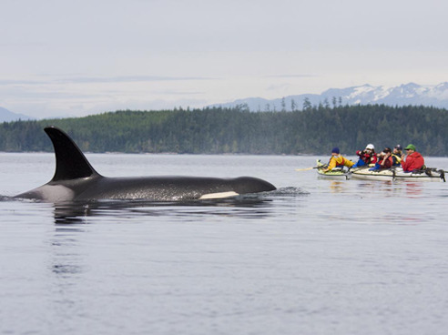
Johnstone Strait, British Columbia
If you want to see whale flukes from the seat of a kayak, head to British Columbia's 40-km-long, 4-km-wide Johnstone Strait. The narrow passage offers perhaps the world's best place to paddle among orcas. Proof lies in the nearby Robson Bight Ecological Reserve, established in 1982 to protect killer whale habitat. A narrow passage separating British Columbia's northern Vancouver Island from the mainland, the strait also features sheltered inlets, islands and estuaries. And whales aren't the only animals to call the passage home; other wildlife you can expect include seals, eagles, dolphins and bear.
Acadia National Park, Maine
Following 325 miles of pristine Maine coast, the Maine Island Trail, created in 1993 and passing directly through Acadia National Park near Penobscot, Maine, was the first water trail created in the U.S. For good reason. It offers paddlers a chance to explore portions of the state's 3,478 miles of coastline and islands, with pre-established launch points and campsites in protected bays. Most agree the crowning feature of the trail is Acadia.
Phuket, Thailand
If paddling in a James Bond setting is what you're after, head to the karst islands of Phuket, Thailand. Here you'll find towering columns rising straight out of Phang Nga Bay, water-filled caves that will have you leaning back in your boat to stare at stalactites, and narrow limestone passages that will force you to place your paddle alongside your craft to get through. All this comes with tropical beaches and clear, blue water that would give even 007 pause from his mission.
Abel Tasman National Park, New Zealand
Little did Dutchman Abel Tasman realize when he spotted New Zealand 360 years ago that the South Island's crown jewel of kayaking would soon be named after him. Located at the north end of the South Island, Abel Tasman National Park boasts more than 37,000 acres to explore by paddlecraft, with sandy beaches for those wishing to camp beneath the Southern Cross and huts for those who prefer shelter. Look for abundant birdlife, seals, emerald-green waters, plentiful hiking trails--and, of course, friendly New Zealand hospitality.
Napali Coast, Kauai
Located on the rugged north coast of Kauai, Hawaii's Napali Coast, used as a trade route by ancient islanders, offers sea kayakers golden, sand beaches, towering coastal cliffs, ancient ruins, pristine snorkeling and at-a-glance beachcombing. It also boasts a variety of sea caves to explore both in and out of your boat, with a few even suitable for camping. If you want, you can also follow the path of the ancients by hiking the old stone path paralleling shore. But the currents and waves can be tricky; check with outfitter Kayak Kauai, (800) 437-3507; www.kayakkauai.com) beforehand.
kurtyang04
·
2014-03-13 21:13
上面重复的有俩个,TETON不能算海洋, 所以17个。
15年内我们策划的目标包括7个+ INSIDE PASSAGE(Glacier Bay,Johnstone Strait) :
阿拉斯加:
Kenai Fjords National Park
Glacier Bay
Prince William Sound
加拿大:
Johnstone Strait
美缅因:
ACADIA
夏威夷:
Napali Coast, Kauai
墨西哥:
Beja
可能性的有5个
希腊
新西兰
斐济
格陵兰
伯利兹堡礁
关于漂流我们团队几乎有实力漂北美95%的河
精品在:
大峡谷红石沙漠峡谷体系, 包括10条以上名河
阿拉斯加和加拿大育空省 10条以上河,世界最野河系列以及众多的冰川河,有几个风格像通天河,但数量多得多 。
kurtyang04
·
2014-03-14 18:06
如果前几年的合作成功,有一个希望就是能找到一些赞助,支援国内经济实力弱点的艇友来北美(我们自己不愁经费)。划艇总的来讲比滑雪和潜水的钱少太多了。关键是机票钱。 过几年我们自己, 包括磨房的朋友是具有向导商业价值, 真希望通过这价值来支援其他国内朋友。
kurtyang04
·
2014-03-14 18:25
这是加拿大最有名的漂流, 中国人听都没听说过的地方:nahanni river trip
难度不大,2-3周,但去目的地要辗转好些地方,麻烦,费用大概1400-1700刀, 包括短途飞机飞到下水点(包括飞机运船)。
一辈子就做一次。近期不会做。
记得我们当年漂阿拉斯加后,再去麦金利山德国家公园,看了那些可能是西半球最高最壮观的山一点没感觉。因为皮划艇的刺激和精彩已远远超过爬一俩天山的感觉。 皮划艇 或技术攀登 是自然旅游的高端大气上档次的一类。
看了麦金利,再看珠峰,还有南美Patagonia, 如果不技术攀登,就那么一回事。
http://www.electricpenguin.com/nahanni/
http://www.waynebarson.com/static_html/trips/pdf/Nahanni.pdf
kurtyang04
·
2014-03-14 18:47
COPPER RIVER (阿拉斯加)2012 我们划了它上游,总有一天完成它的下游。它的下游是世界漂流里唯一岸边有大面积的冰川。 它上游岸边并不贴近冰川,但离冰川源头就10公里, 也称冰川河。
我们去过风景奇美的红土峡谷,很多白水激流的高山峡谷,但最打动我们的就是阿拉斯加的漂流。
 kurtyang04
·
2014-03-14 19:15
kurtyang04
·
2014-03-14 19:15
经常,在北美的海洋皮划艇死忠分子里,经常看到老头老太。
在阿拉斯加COPPER RIVER 我们完成了支流的漂流上岸时,见到了一批60-70多退休的老头老太, 要用几个大筏完成600公里的全部漂流(我们颤颤惊惊完成上游) ,其中一个筏子,全部是酒类。他们说,人生有三四十个漂流目标, 这是他们进行的第十一个。
这个深深刺激我们每一个同学,多么潇洒的人生。 同时告示我们,皮划艇是一个没有年纪约束的极限运动,皮划艇也非常贴近生活, 而不是其他极限运动那么苦逼, 对体力要求比较接近普通人。
kurtyang04
·
2014-03-14 19:49
关于签证,我会发动很多队员写推荐信。在我们的圈内,哈佛和麻省理工的同学就有十几位。哈佛和麻省理工同学的推荐,是管点用的。分布在北美其他地方的队员,还能提供别的方便。
还有感觉这是种小赌,北美户外不但不贵,而且环境那个纯净,没有任何铜臭感觉,任何东西明码标价,户外重地从来没有经历被宰。 拿到一次签证,就是一辈子通行证。皮划艇朋友有一些经济保障的同学,要么不出国,如要出国户外,这个赌我觉得要押在北美上。
美国毫无疑问还是世界购物天堂,购物省下来的钱,希望能抵消部分机票的费用。
kurtyang04
·
2014-04-11 04:33
一切为了心中的阿拉斯加:
无论是今年还是当地的活动,所有的努力都指向一个两年三年后目标:就是梦中的阿拉斯加海洋。
因为要参加最好朋友迟到8年的婚礼,下周直飞西雅图,多请两天假,有四五天考察inside passage 的起点,也是头次为海洋舟探险开路。
kurtyang04
·
2014-06-05 21:05
为了心目中的冰川海洋舟,同时接受台湾同学的批评,我们将集中训练我们的基本功。我们的海洋舟基地也有去年年初的5人,到去年底15人,年初的20人,再次提升到30人。
连续三周练习内容:
基本练习之一:The Scramble
基本练习之二The Wet Exit
基本练习之4 Low Braces
基本练习之三:The Stern Rudder
基本练习之5 The Paddle Float Rescue
基本练习之6 Low Brace Turn
基本练习之7 Kayak T Rescues
基本练习之8 Sea Kayak - Paddle Float Balance Brace - Rolling
kurtyang04
·
2014-06-05 21:19
我们已敲定了今年的INSide passage 计划,和2016-2018年阿拉斯加 GLACIER BAY计划,以及资格标准,一切的训练就是为了心中的海洋舟冰川。
按照预计计划,我们将邀请两位大陆艇友参加2016计划。
2014计划我们不邀请国内朋友,作为首次海洋舟国际计划,风险大,我们先磨合美国的华人艇友。 希望拿下首仗。
目前报名8月底活动的大概有7位,3位西部大侠级艇友,和4位东部基地的老朋友,西部两位大侠是首次参加活动, 另一位已经合作4年,而且夏天来BOSTON出差一个月,一起为海洋, 和大峡谷漂流进行训练。
kurtyang04
·
2014-06-05 21:33
5/24-26我们进行了第一次inside passage 有关训练,汲取五月初的教训,全面围堵漏洞,打了一个胜仗,同时两位女将分别带领俩个22, 14km的活动,漂亮完成,我们已经培养或引导了未来华人里最好的女性海洋舟艇友。
kurtyang04
·
2014-06-05 21:36
我们又敲定2014/11月底另一个计划,佛罗里达的海洋舟,皮划艇女生未来之星ROBIN已拿下机票。预测十多位同学会加入以海洋舟为主,潜水浮浅为辅的活动, 只有5天集体活动时间。
本次活动难度不高,对国内朋友开放报名,但这次我们不做太多签证帮助,只提供邀请函和美国当地海洋舟俱乐部的推荐信。
我们越来越相信这种国际合作海洋舟漂流活动,是打开未来的一串钥匙,是我们的机会,也是磨房的机会,更是超越自己的机会,心中装有世界才能飞得越高越远。
kurtyang04
·
2014-06-05 23:25
回想一些事,觉得磨房的朋友心胸开阔些。 我并没有把我们最好的活动照片发在任何坛上, 只发的是训练性质的照片,而这里的朋友是慧眼识豪杰, 给了足够的信任。
今天再盘算GLACIER BAY活动人数时,发现我能指挥动的猛将多达二三十位,但我不满足,还在训练第五第六年新人,5-3/4的活动照片都是那些最新新人,一些人照片幼稚自然是正常地,况且其中也有俩位非常好的料子, 未来的猛将,但被某岛国人打到划SITONTOP的级别,人不可貌相,海水不能斗量,第一次感受到一些狭隘地区出来人的心胸。
我团队不就是缺些基本功吗,一旦恶补上,有世界十大缅因在身边,再划上INSIDE PASSAGE, 我们的前边还有哪个团队。
在我这个总指挥总策划思维里,堵住恶性事故发生是第一位,基本功第二位,当然基本功与安全息息相关,有了基本功并不能保证安全。到今天,我仔细了解了海洋舟发生事故的规律,发现了关键的救援方法,大局在握情况下,基本功自然是下一个重点,这叫水到渠成。
7年的辛酸苦甜,就是那么几句话,安全首位,不屈服失败,从一开始就尊重人才,人才是户外的本。
一点感叹。
欢迎国内艇友加入我们团队,7年我们的心血就是造就了这么一支团队, 我很为自己的团队骄傲,也相信国内朋友和我们合作是锦上添花。
kurtyang04
·
2014-08-12 20:23
我们调整了计划,把难度大的INSIDE PASSAGE放在明后年,转攻加拿大东海岸的NOVA SCOTIA
因素
1)NOVA SCOTIA 难度低一级, 更接近我们基地的环境条件
2)无需坐飞机,大概1000多公里的车程(单),可以带熟悉的自家船
3) 后勤可以完全从本地带过去
4) 可进可退
为了争取胜仗的有利因素,我们采取了天时地利人和的方案
kurtyang04
·
2014-08-12 20:29
这个行程本月底就开始, 由于是跨国签证,只有三位三级队员无需签证同学参加,两男一女。包括开车路程是九天。
这是我们海洋舟第一个多日探险项目(漂流我们已积累了四个), 国际的第一个。
我们第二次活动今年11月底在佛罗里达开展,对国内艇友开放。
kurtyang04
·
2014-08-12 20:35

The year was l756. The small group of Acadians dragged birch bark canoes over the slippery expanse of cobblestone as the rising tide followed. On the crest of the barrier beach they rested, contemplating the sight in silence. There was no sign of human habitation. The deeply incised valley sliced into the sheer escarpment, opening up slopes of dense coastal forest that crawled up onto the fog enshrouded plateau. They had travelled a long way, and they were despondent. The refugees knew that they would never see their homes again.
Two centuries ago Refugee Cove was a desolated sanctuary for the fleeing Acadians only a short while. They had to move on, pursued by hunger and the British. Later on, in the l800’s, there was a flurry of lumbering activity but by the early part of this century the coastline of Cape Chignecto had again settled into obscurity and, until recently, it has remained forgotten and ignored.
“Cape Chignecto is truly a spectacular place.” Howard Donohoe should know. As a geologist with Nova Scotia’s Dept. of Natural Resources, he has probably explored the cracks and crevices of this shore more than anyone else. His geological map of the Cobequid Highlands, a patchwork of colours and symbols, tells a complex tale of transformation.
According to Howard, “the 30 kilometres from West Advocate to Apple River has a geological diversity unmatched anywhere else in the province. It is perhaps the best place to interpret Nova Scotia’s earth history.
To understand and appreciate the importance of this Cape we must go back over 400 million years, to a pivotal period in the development of the earth. During the middle of the Paleozoic era the continents, constantly migrating on crystal plates, had fused into a single land mass. The collision was cataclysmic. The crust was compressed and folded into mountain chains thousands of feet high (the Appalachians date from this period).
It fractured and faulted, and molten magma intruded into the fissures and out over the surface. During the millions of years that followed, shifting of the crystal plates caused readjustments within the gigantic supercontinent and the various structures that were to form our province moved into place. The climate was hot and desert-like and the world belonged to the dinosaurs.
Eventually, conditions within the earth’s core changed and the supercontinent began to break apart. At the collision boundary, faults opened, huge sections dropped and were filled with sediment, and lava again spewed forth. Both sides of the Cape area are remnants of this tortured period.
However, the final split occurred much farther to the east, at the edge of the continental shelf, and a huge chunk of ancient Africa was left attached to North America. Erosion has since worn down the mountains and exposed the underlying bedrock. Huge river formed channels leading to the sea which the glacier enlarged to form a bay with the highest tides on earth.
The majesty of Cape Chignecto is the shoreline. The southern coast parallels the Cobequid fault, extending across the province and out under the Atlantic. This is the ancient collision boundary. More than a dozen rock types form the side of the raised plateau beginning with the relaltively young red Triassic sandstone of West Advocate. Ancient grey slate and siltstone follow, melting into bright reddish-tan granite, infused with undulating ribbons of black diabase. The evolution of these features is complex but, even without understanding their origins, the contrasting colours, textures and forms are striking. Sea caves, shoals and beaches come and go with the tides under the intimidating shadows of sheer cliffs, up to 700 feet, the highest on mainland Nova Scotia. Dark-green wrecked dangles overhead, under scraggy trees which cling precariously to the cliffs.
Refugee Cove is the only significant break in the southern escarpment. The high cobblestone beach is littered with errant logs and bleached trees, evidence of the severity of the winter storms that lash these shores. Behind this barrier, at the far edge of the sheltered flood plain, the remains of a brick oven suggest a sawmill, but little else describes the past and nothing at all form the time of the Acadians. As recently as the l930’s, logs and lumber produced here were towed on scows of rafts to markets far away.
In the distance to the west, Isle Haute emerges as an impenetrable fortress, its sheer basalt walls vestiges of ancient basalt lava flows, that now line the bottom of the Bay. It is best viewed from French Lookout, a grassy promontory at the edge of the sharp from where those early refugees scanned the waters for any sign of the British.
To the east, the golden cliffs of Cape door glisten in a late afternoon sun, no different from the days when Champlain visited them in search of copper while en route to found the first European settlement in Canada. At the very tip of the Cape, the igneous rock of the Cobequid Mountains gradually slides under the waters of the Bay.
The western shoreline is also a legacy of continental rifting, a breaking apart that didn't quite succeed. The cliffs are largely unassailable although lower than on the south shore and with numerous pocket coves that provide passage to a gently sloping plateau. Streams often arrive at the beach in a waterfall, a tempting cool shower during hot summer days.
Shoals and spires hug the coast and lead the adventurous through a tricky maze of winding channels where harbour seals share the ledges with olive-green seaweed. Exposed reefs, the colour of limestone, are actually blankets of barnacles waiting out another tidal cycle. High overhead, bald eagles play in the updrafts and at Green Point, a large Herring Gull colony guards the approaches to Eatonville, another deserted harbour.
When the Europeans arrived in the Bay of Fundy, settlement spread rapidly and, by the end of the last century, every cove, inlet and river mouth that could be adapted for anchorage became the site of a mill or a shipyard. Eatonville was one such place. Here in an obscure river valley between the Cape and Apple River, the Eaton brothers established a thriving lumbering and shipbuilding operation in the 1870’s.
This was Nova Scotia’s golden age when our sailing ships could be found throughout the globe. But by the turn of this century, with iron and steam replacing wood and wind, the decline had begun and by 1920 there was little left. Another bustling Maritime community had been abandoned.
A tidal river, hugging the sculpted walls, leads into the former settlement along a bank of old wharf pilings. Fragmented bricks and rotted beams are strewn above high tide among goose berry bushes. The cribs which carried the wooden tramway up to the plateau still rest on the river bed but there is no sigh of the mill.
In his book, Sails of Fundy, Stanley Spicer lists 21 vessels which were constructed in Eatonville. Although that may not seem like a lot, considering that over 600 (including the famous mystery ship, the Mary Celeste) were launched from the Parrsboro shore alone, what they lacked in numbers they made up for in size. Seven of the largest were built in this cove and the leading one, appropriately christened the D.R. Eaton, weighed over l,550 tons. This was enormous in an era when the world record barely exceeded 2,600 tons. By comparison, Nova Scotia’s current sailing ambassador, the Bluenose II (at 99 tons) would be dwarfed alongside.
Outside the harbour entrance lies a bizarre moonscape of arches, caves, tunnels and sheer pinnacles, fashioned by the constant erosion of the sea, and highlighted by the Three Sisters. At low tide you can explore among these towering spires on foot, but when the water returns there is no escape except by boat.
The geological diversity doesn’t stop with Eatonville and at Squally Point we find the highest raised beach in the province, l00 feet above sea level. This is a legacy from the Ice Age, a result of the land rebounding with the melting of the glaciers faster than the rise in sea level. Further along, in Spicers Cove, younger cliffs of conglomerate crumbling to the touch, litter the shoreline with their resistant constituent stones. There are even small coal seams exposed near the beach. At Apple River the sandstone, a gently sloping shoreline, and the renowned Bay of Fundy mud have returned.
My fascination with Cape Chignecto has brought me back again and again during the past several years, and I sometimes bring along friends who think they have seen the best that the east coast has to offer. While tourists may round the Cabot Trail, sun on P.E.I.’s beaches or marvel at the Hopewell flowerpots, no sighs point the way here - to the most spectacular region of all.
However, that is about to change. Through the tenacious efforts of several individuals and groups, the province has been moved to acquire the Cape. The ultimate goal is to develop it as a wilderness park, protecting a precious natural resource for future generations, while at the same time assisting in the long-term development of an economically disadvantaged area.

The tides and currents of the Bay of Fundy are legendary and to someone used to the more moderate ebb and flow along other coastlines they are indeed spectacular. In the upper reaches of the Bay the tidal differential can exceed l5 meters (the highest on earth - 12 meters at Cape Chignecto) and when it is out, enormous expanses of mud flats extend kilometres from the shore. In some channels and around headlands currents can reach several knots and during bad weather, especially with an opposing wind, they can be treacherous for small craft. It is this powerful, ceaseless movement that has sculpted caves spires, arches and all manner of monoliths form the resistant rock.
For those of you who feel uncomfortable with coastal paddling in general,the notion of testing these waters may seem foolhardy. This isn’t so. I have travelled these waters in both kayak and canoe, with novices and experts and have yet to encounter a major problem. But like driving, where one would be well advised to stick to the right hand side of the road, there are conditions here which must be understood and accommodated. Be prudent and stay close to shore. Always be wary of headlands and don’t leave in questionable weather. Don’t overestimate your skill level, nor underestimate the rapidity in which conditions can change. Better still, travel with a knowledgeable companion until you become familiar with these unique waters.
Rather than being carried out to sea or sucked under in the mythical whirlpool (one of which I have yet to see) my most common initial problem involved miscalculating the tidal range. More than once I have been obliged to scurry after a piece of equipment floating away towards New England. A more chilling (literally) surprise would be pitching a tent in that flat patch of salt hay at the wrong time of the month!

Although Refugee Cove and Eatonville are the best sites for camping, there are others on the western shore and, in an emergency, you can land at several small beaches. Bring extra rations. This is an open coast and the weather can veer with little warning. If you become stranded the cliffs may prevent an exit over the plateau. Be especially wary during the tide change. The wind may alter direction and if it confronts the flow treacherous standing waves may be the result.. Time your arrival in Apple River to high water or you will have either a long wait or a long drag - over ankle deep mud.
Note that the water temperature in the Bay rarely exceeds 55 Fahrenheit, even in late summer. The tidal mixing brings the cooler bottom water to the surface rendering swimming and snorkeling unattractive and an unexpected spill are from shore dangerous (however, it is usually still warmer in this end of the Bay than I have found in off Castine, Maine). Fog often persists late into the season as warm moisture-laden air from inland condenses over the bay. A hot sunny day in the interior is no indication of what to expect at the Cape, especially early in summer.
Cape Chignecto is off the beaten track and to reach it you exit the Transcanada highway when crossing into Nova Scotia at Amherst. A provincial road map will get you there. You can put in at either West Advocate or Apple River depending upon when you wish to cope with those mud flats. Allow three days for the trip. If conditions are good you can complete it quicker but the beauty warrants a logner stay. If you travel through Joggins, on Chignecto Bay, stop for a fossil hunt along the beach. There are plenty to be found and any on the ground are yours. In Parsboro, along the Minas Basin, semi-preciousstones are present in the basalt cliffs. Check in at a local gem shop for directions on how and where.
kurtyang04
·
2014-08-12 20:38
我们选中的第一个是 CAPE CHIGNECTO 省立公园, 已定好三晚在公园里皮划艇露营, 上面的见解来自权威的NS向导书作者。
kurtyang04
·
2014-08-12 20:45
我们选中第二个是 不太容易的cape brenton 国家公园,这个我们保守地选择容易部分,把很挑战部分留给以后。
著名的一个景观是鲸鱼,不过能不能看得到,我把期望值放到0, 能安全下海就是成功。
http://www.coastaladventures.com/highlandsarticle.html
 kurtyang04
·
2014-08-25 20:47
kurtyang04
·
2014-08-25 20:47
带着一个整夏天的训练和技术积累,周五要上路了,开车是单程1000多公里,预测开车共2400公里,一共三人,俩男一女,九天, 汽车头顶两只硬艇,一只软艇 , 唯一的遗憾,考虑安全因素,没敢带我们的英国船PINTAIL。
kurtyang04
·
2014-09-09 01:41
下一站,11月下美国的佛罗里达。 公开给有机会在美访问的朋友。(AA制)
kurtyang04
·
2014-11-10 20:01
中新网北京11月10日电 (记者 魏晞 蒋涛)美国总统奥巴马11月10日出席2014年亚太经合组织工商领导人峰会,并发表演讲。他表示,此次访问期间,美中两国同意作出新的签证安排,让学 生、游客都受益。新的安排下,学生签证有效期最长将延长至5年,商业旅游签证将延长到10年
2013年,大约180万中国游客来美国旅游,仅加州就接待了60万名中国游客。估计2014年来美旅游的中国游客将达到210万人,2015年达到260万人,超过巴西的250万人。预计未来三年,中国仅次于英国,成为北美洲以外第二多游客来美国旅游的国家。
200万人里一个也没有来,皮划艇地,一是悲哀,二是来美旅游大部分还是停在风光游。
赞,坐等看大片
好向往,但是10米巨浪和27KM/H流速令人望而却步:sad:
你们的漂流路线太美啦!很想亲自去试试、、、您还能给我推荐一下关于户外的论坛或者网站么?
这辈子机会总是有的,好好工作。等机会成熟,来找我把。
网站连接我明天上午贴出。
流口水的就是阿拉斯加冰川。和育空河。Johnstone Strait还没怎么了解过。提前发下行程,可以看看可行性,就签证而言,加拿大最划算,现在给的都是十年多次签证。还不用面签。
好呀,我奔回国内就是寻找像鸟大侠一样的朋友,签证我可以找美国人写推荐信,中国社团写邀请函,总有一天会成功地。来日方长,冰川海洋舟我们放在2016/2017,有两年为签证和活动准备。
前年我们完成一个冰川河后,yukon对我们没有难度,只有请假问题,也早被我队员催了,大概有等7/8年后把。
开始集结队伍了。
一个奇迹的开始
关注,居然有一两个是我意淫了好久的线路,包括下龙湾。另外,帕劳和台湾都可以考虑。
本人美签大多数时候是有效的,一年出差去一次也是有机会的。但时间配合上恐怕没那么容易。
太好了,总有机会,出差前几个月到半年通知我们,我们查看机会,几年后我大概更机动。
先來HK吧!還有很多有趣的線路.
呵呵!问好老夫子,我今年可是要来了~
是,如果香港不太贵的话,是跨洋活动的好练习。
不太貴的.又HK有海岸保護區.沙灘又多.沿海路又可露營.一路划船一路可看珊瑚和潛水.那機會成本就回來了.
海洋舟旅行的顶级线路,绝对充满挑战,预祝楼主的活动顺利成行!
我有划艇从然乌湖到来古冰川的筹划,预计在2015年,到时也看有无同好一起~
这个好地方都被你发现了,的确非常不错,到时候多贴点信息。 说不定过5年10年有机会跟大侠您合作项目。
歡喜...歡迎....HK也有不少船可租的.
经常,在北美的海洋皮划艇死忠分子里,经常看到老头老太。 在阿拉斯加COPPER RIVER 我们完成了支流的漂流上岸时,见到了一批60-70多退休的老头老太, 要用几个大筏完成600公里的全部漂流(我们颤颤惊惊完成上游) ,其中一个筏子,全…
现在厦门 划艇速度最快 耐力最好的是58岁的郭哥 郭哥现在就特别有目标 我们年轻一辈很受鼓舞
关于签证,我会发动很多队员写推荐信。在我们的圈内,哈佛和麻省理工的同学就有十几位。哈佛和麻省理工同学的推荐,是管点用的。分布在北美其他地方的队员,还能提供别的方便。 还有感觉这是种小赌,北美户外不但不贵,而且环境那个纯净,没有任何铜臭感觉,…
目前美国签证不需推荐信,只要不是白本护照,有正常的工作,一般是不难签的。1000RMB一年多次入境。
国内往返西岸机票,不是旺季提前购买的话估计最低4K~6K可拿到。
这风光,:heart:太销魂了
遠機票價錢比較吸引
太喜欢划艇了。。。。
好久没有上磨房了:)
@Kurt 见到你整理的各种活动信息/材料和这个长远规划,真是有热情和行动力啊!很是佩服。
对于训练计划,小小补充,供参考:
1. 使用工具进行自我定位、导航和通讯?- 不单单领队,队员也需要具备一定的能力,预备出现与领队失去联系的情况
2. 根据天气潮汐水情制订备用计划和临时预案的能力? - 同上
3. H rescue / other types of rescue that involves 2 boats on the water and 1 swimmer with a capsized kayak - in many occasions the situation that causes a capsize in your team (particularly big wave or choppy areas) may make a T rescue very difficult for both the paddler and the swimmer. So consider to practice a more "reliable" rescue type even it may require more boats on the water and longer time.
4. 风浪中的单人水中上艇 或是under water wet entry以后roll back - 这个虽然不大可能要求每人必须完成,但是你的团队中能够完成的人越多,团队的能力会增强很多,安全保障系数也会高很多。
5. 高效率前进桨 - 所谓以leg drive - torso rotation为主要动力来源的划艇方式。提高团队的单日续航能力和突破洋流的速度能力 - 这个的意义我想你肯定懂的:)
最后想再啰嗦一点,这种长途旅行装备其实非常重要。我估计你的其他器材都可以自带,但是艇本身可能难以避免在某些情况下要问当地租,那么艇的长/宽/rocker/hull shape/back deck hight/cockpit rim / etc... 都可能对安全造成很大影响,尤其在使用者不熟悉的情况下。可能需要考虑提前熟悉。
祝顺利!
谢谢147大侠,我想能自己带艇是我们改变今年策略的主要因素之一,还是自己的艇放心,尤其一个划艇时间不算长的队伍。连选择艇,我否决了VALLEY这些适合玩浪但不特别稳的船,稳定性压倒一切。
划的路线难度完全根据救援能力决定,我们三人的队伍基本是中级队伍,无法完成大风大浪救援,所以天气不好,一律不出战,在训练大家都认同我这个观念。还有不远离SHELTER, 选择没有潮汐流多大影响,风影响不太大的路线。团队已经磨合了至少7天以上。
带着一个整夏天的训练和技术积累,周五要上路了,开车是单程1000多公里,预测开车共2400公里,一共三人,俩男一女,九天, 汽车头顶两只硬艇,一只软艇 , 唯一的遗憾,考虑安全因素,没敢带我们的英国船PINTAIL。
祝顺利!记得多拍些照片上来分享啊,呵呵。
谢谢游兄! 刚完成第一目标,名不虚传。
期待照片
都是仙境啊!此生必须去几次!
如果有机会来北美划艇,本人奉陪。
先提高自己,等到时机成熟一定要参加!~
是呀,这是通向未来的一条路。