1. Satellite distribution
2. Position
3. Navigation
4. Map: Max 3,840 marks can be added
5. Route (20 routes, 31,084 route dots, 3,120 waypoints)
6. Go To
7. Database
8. Set Up (includes an interesting "mirror" mode)
9. Bluetooth On/Off toggle
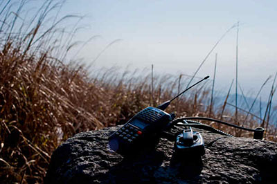
The GPSmart belongs to a category of its own when it comes to dedicated PDA/PC receivers, since it's the first unit that allows for standalone operation, even while it's feeding the standard NMEA data over the Bluetooth connection.
"Slave" Operation
I used the GPSmart in Bluetooth mode connected to my iPaq and Dell via a Socket BT CF card and to my laptop using a USB Bluetooth adapter. The manual includes a long list of optional cables for connection to all current PalmOS and PocketPC (except the Dell or iPaq 1910 PPCs). In the meantime, I also connected to the GPSmart via USB with my laptop (more on this later). There really isn't much to say here. Just initiate a BT search from your PocketPC, connect to it over a virtual COM port and the unit will start feeding NMEA data to the software you're using.
The nice touch here is that the unit remains fully functional as a standalone unit even while its sending data over BT. This will let you (or rather your passengers...) navigate the menus, check the satellite status, position, speed, etc...while your navigation program on your PocketPC tracks your position on the road. An added bonus is that you can be connected via the USB port at the same time as via BT, so you can also feed data to a laptop or USB enabled PocketPC and a BT unit.
"Standalone" Operation
This is new ground for the site, since previous units reviewed could not operate as standalone units. I'm a little hesitant to delve too much into this aspect of things where the gpsinformation guys would do a much better job ;-) Since this is the first review of the GPSmart, I'll take a bit of a plunge and will describe the main functions. I've uploaded the manual in .pdf format, so people interested in getting more details can use it as a reference.
Satellite distribution:
Lets you monitor the satellite reception with bars for strength, a "compass" and a status icon 2D/3D
Position:
This screen will show your:
latitude
longitude
Type of GPS fix
Altitude
Local Time (adjustable)
Speed (mph or kmph)
By pressing the up and down buttons, you can toggle between metric and imperial
Navigation:
This screen will show:
top part: compass (drawing, no digits)
bottom part: speed/position/altitude/local time/timer - toggled by pressing up/down functions
You can access options for each type of information by pressing the "enter button", i.e in position mode you can select either the degree or the degree, minute, second format.
Route:
This is the mode that lets you record a path to be able to backtrack or follow it again in the future by recalling it. Note that this is fairly basic as you will be following the dots on the screen and won't get any distance to route, distance to go, etc...
A total of 20 routes can be saved, using 31,084 "dots" and 3,120 waypoints with 156 max per route.
The screen is divided as follows:
top 2/3rds show your route being plotted
bottom 1/3rd shows the same information as the bottom part of the "Navigation" mode
You can save waypoints as you go along by entering the menu
You can set the time interval for "dots" and zoom in and out
Note that you can't transfer the recorded data via the Bluetooth or USB connections towards another device
Go To:
In this mode, the GPSmart will guide you to a target and will no doubt be a geocacher's favorite!
The screen is divided as follows:
top 1/3rd: the name of the target and its lat/long
middle 1/3rd: compass showing the heading of the target, no digits though
bottom 1/3rd: same information as the bottom part of the "Navigation" mode with the addition of a "distance to" screen
The target can be chosen from a list of waypoints and marks and you can also input a lat/long although the latter is a bit time consuming since you have to scroll through digits.
Map:
In this mode, the GPSmart will display a map with your position, recorded waypoints and marks and a small compass in the top right corner
You can record marks (give it a name and an icon base on category), zoom in and out and use the timer.
Area Calculate:
As the name implies, this will let you calculate an area by walking around the place you are surveying. Can come in handy when you're house hunting (for the garden of course)
You can choose Square Km, Square Miles and Acres as units
Database:
This mode will let you manage your database of routes, waypoints and marks by renaming or deleting them
Setup:
Set the time zone (GMT, +1, -1, etc...)
Switch to mirror display, at which point you'll need a mirror to be able to read the data ;-) I haven't figured in which case this could be handy but it certainly doesn't hurt to have the option!
Change from metric to the imperial system
Clean the memory
Bluetooth On/Off toggle: not much to add ;-)
All in all a fairly intuitive set of operations that can be done one-handed. Similarly to the design, nothing fancy here compared with what units like the eTrex do, but it gets the job done. The "Go To" mode is a good example of this, very easy to set up and effective. I wish it were possible to transfer the recorded data (routes, waypoints, marks) via the Bluetooth or USB connections towards other devices.
Feature & Specification:
• Bluetooth handheld GPS receiver/sensor
• NMEA data logger
• Audible alarms for speed, altitude and proximity
• Waterproof and floatable
• File downloads supported by OziExplorer
The Navi GPS is a Bluetooth device that can be used as a handheld receiver and as a remote GPS sensor. It offers everything a non-mapping handheld does and also acts as a wireless sensor for your PDA or Laptop. It supports differential corrections from WAAS or DGPS.
The unit also supports SD/MMC cards for logging NMEA GPS data (to the capacity of the data card). The Navi GPS can collect waypoints and tracks internally, and can calculate an area based on a track log. Navi GPS also supports waypoint routing and navigational features such as a trip computer. You can use the unit for recreation or work. The unit is by far the most versatile Bluetooth GPS available.
Features
• Bluetooth (for use with a PDA & PC)
• SD expansion slot up to 2Gb
• GPS data logging on SD card (GGA, GLL, GSA, GSV, RMC, VTG, ZDA)
• Proximity waypoint alarms 10m - 1Km
• Speed alerts 30-150Km
• Altitude alerts; above or below
• Built in Antenna
• LCD Screen, Thumb stick (enter button), Power/ESC Button
• Waypoints, tracks, and wayoint route capable
• Built in calendar
• Trip computer
• Stop watch
• Satellite info screen
• Area calculation
• Configurable map datum, user grid, position format
• Waterproof and it floats!
• Much more
Specifications
• Waypoints - 1000 with name and graphic symbol
• Routes - 20 with max 125 waypoints each
• Tracks - 1 with 8192 points
• Trip computer - Odometer, trip timer, current speed, maximum speed, sunrise, sunset...
• Alarms - Monotone, red LED
GPS Specs
• 12 channel L1 receiver
• Acquisition time 8/38/45 (hot/warm/cold start)
• Update rate 1Hz
• Dynamics - Speed (max): 515 m/s, Altitude (max): 18000m, Acceleration (max): 4g
• Differential - DGPS and WAAS
• Antenna - embedded patch antenna
• Power source - Built-in litium ion polymer rechargeable battery, external power
• Battery life 10~16Hrs (AC & DC chargers included)
• Communications - Bluetooth and USB
• Data formats - NMEA 0183, RTCM 104, SiRF Binary format
• Memory card - SD/MMC slot
• Dimensions 90H x 58W x 24.5D (mm)
• Weight 3.4 oz (96g) including battery
• Display:
Black/white, FSTN, Transflective
1.5 inch diagonal [33W x 21H(mm)]
128 x 64 pixels
LED backlit
• Water proof (IEC529 IPX7)
• EMC standard CE, FCC
Contents :
• Navi GPS Bluetooth unit
• Car charger
• AC charger
• USB interface cable
• Installation CD
• Bike mounting Kit
蓝牙GPS,是PDA用的吗? 我在PDAFANS上看到有一款才卖8百多,不知道效果怎样。
这款是手持机,并且带兰牙功能,能独立使用,也可以用兰牙或usb线连接PDA或笔记本使用,台湾产的,不知道有没有中文界面。
2
3
看来防水性能不怎样
可以通过usb口充电及传输数据,不知道是否包含usb线
1. Satellite distribution
2. Position
3. Navigation
4. Map: Max 3,840 marks can be added
5. Route (20 routes, 31,084 route dots, 3,120 waypoints)
6. Go To
7. Database
8. Set Up (includes an interesting "mirror" mode)
9. Bluetooth On/Off toggle
不理解这句话 5. Route (20 routes, 31,084 route dots, 3,120 waypoints)
如果是说可以存31,084个轨迹点的话,那可是我知道的手持机中最大容量的3倍多了。
- Device: 58(W) x 119.5(L) x 30(H) mm
- Screen area: 80 x 50 mm
- Screen size: 66 x 33 mm
- Screen resolution: 128 x 64 pixels
看来屏幕清晰度不高
Operation:
The GPSmart belongs to a category of its own when it comes to dedicated PDA/PC receivers, since it's the first unit that allows for standalone operation, even while it's feeding the standard NMEA data over the Bluetooth connection.
"Slave" Operation
I used the GPSmart in Bluetooth mode connected to my iPaq and Dell via a Socket BT CF card and to my laptop using a USB Bluetooth adapter. The manual includes a long list of optional cables for connection to all current PalmOS and PocketPC (except the Dell or iPaq 1910 PPCs). In the meantime, I also connected to the GPSmart via USB with my laptop (more on this later). There really isn't much to say here. Just initiate a BT search from your PocketPC, connect to it over a virtual COM port and the unit will start feeding NMEA data to the software you're using.
The nice touch here is that the unit remains fully functional as a standalone unit even while its sending data over BT. This will let you (or rather your passengers...) navigate the menus, check the satellite status, position, speed, etc...while your navigation program on your PocketPC tracks your position on the road. An added bonus is that you can be connected via the USB port at the same time as via BT, so you can also feed data to a laptop or USB enabled PocketPC and a BT unit.
"Standalone" Operation
This is new ground for the site, since previous units reviewed could not operate as standalone units. I'm a little hesitant to delve too much into this aspect of things where the gpsinformation guys would do a much better job ;-) Since this is the first review of the GPSmart, I'll take a bit of a plunge and will describe the main functions. I've uploaded the manual in .pdf format, so people interested in getting more details can use it as a reference.
Satellite distribution:
Lets you monitor the satellite reception with bars for strength, a "compass" and a status icon 2D/3D
Position:
This screen will show your:
latitude
longitude
Type of GPS fix
Altitude
Local Time (adjustable)
Speed (mph or kmph)
By pressing the up and down buttons, you can toggle between metric and imperial
Navigation:
This screen will show:
top part: compass (drawing, no digits)
bottom part: speed/position/altitude/local time/timer - toggled by pressing up/down functions
You can access options for each type of information by pressing the "enter button", i.e in position mode you can select either the degree or the degree, minute, second format.
Route:
This is the mode that lets you record a path to be able to backtrack or follow it again in the future by recalling it. Note that this is fairly basic as you will be following the dots on the screen and won't get any distance to route, distance to go, etc...
A total of 20 routes can be saved, using 31,084 "dots" and 3,120 waypoints with 156 max per route.
The screen is divided as follows:
top 2/3rds show your route being plotted
bottom 1/3rd shows the same information as the bottom part of the "Navigation" mode
You can save waypoints as you go along by entering the menu
You can set the time interval for "dots" and zoom in and out
Note that you can't transfer the recorded data via the Bluetooth or USB connections towards another device
Go To:
In this mode, the GPSmart will guide you to a target and will no doubt be a geocacher's favorite!
The screen is divided as follows:
top 1/3rd: the name of the target and its lat/long
middle 1/3rd: compass showing the heading of the target, no digits though
bottom 1/3rd: same information as the bottom part of the "Navigation" mode with the addition of a "distance to" screen
The target can be chosen from a list of waypoints and marks and you can also input a lat/long although the latter is a bit time consuming since you have to scroll through digits.
Map:
In this mode, the GPSmart will display a map with your position, recorded waypoints and marks and a small compass in the top right corner
You can record marks (give it a name and an icon base on category), zoom in and out and use the timer.
Area Calculate:
As the name implies, this will let you calculate an area by walking around the place you are surveying. Can come in handy when you're house hunting (for the garden of course)
You can choose Square Km, Square Miles and Acres as units
Database:
This mode will let you manage your database of routes, waypoints and marks by renaming or deleting them
Setup:
Set the time zone (GMT, +1, -1, etc...)
Switch to mirror display, at which point you'll need a mirror to be able to read the data ;-) I haven't figured in which case this could be handy but it certainly doesn't hurt to have the option!
Change from metric to the imperial system
Clean the memory
Bluetooth On/Off toggle: not much to add ;-)
All in all a fairly intuitive set of operations that can be done one-handed. Similarly to the design, nothing fancy here compared with what units like the eTrex do, but it gets the job done. The "Go To" mode is a good example of this, very easy to set up and effective. I wish it were possible to transfer the recorded data (routes, waypoints, marks) via the Bluetooth or USB connections towards other devices.
下面是说明书http://www.gpspassion.com/pics/GPSmart%20BT%20manual.pdf
个人觉得从手持机来说,菜单及总的界面不够GARMIN的好,只能满足基本使用,没有花哨功能,防水性欠缺,屏幕够大但不细腻。
好处是兰牙功能,市面上光兰牙功能的接收机就要1000多了,有USB口,不用买com转usb线,内存轨迹数超大,3w多,garmin的最多1w(这个我最喜欢,开车旅游几天都不需要上传轨迹)。车载非常合适。
可惜我有太多gps了,不能买了,谁需要gps,强烈推荐!但后果自负
有没有卖的?
有人用过了吗?才1435元: http://www.expansys.cn/product.asp?code=GPSMART
个人感觉比单纯的蓝牙GPS Mouse 更有用。
这款市面上唯一的 手持机+蓝牙 已经停产了,这是厂家给我的回复:
另外找了一款带蓝牙的手持机:http://cgi.ebay.com/NAViGPS-Bluetooth-Handheld-Navigator-Data-Logger_W0QQitemZ5861126284QQcategoryZ4668QQcmdZViewItem
,不过说明中没有提到是用几代的芯片。
NAVi也算是GPS专业厂家了,国内有几款车的原厂车载GPS就是NAVi供货的。
其实在现有手持机基础上加个外置蓝牙模块也可以啊,广州就有人做的。
是的,详见:http://www.doyouhike.net/forum/175559,0,0,1.html
我自己也能做,但是,就是想买一个可靠的成品,呵呵。