据称:是世界上第一款集成了双向通信无线电对讲功能的GPS接收机。
通讯特性:
通讯频道:20个信道(每个信道含38个静噪码)
通话功能(VOX):免持无线通话功能(VOX):将VOX耳机接入无线对讲机后,无需按键即可直接通话
使用范围:3公里
GPS特性:
定位精度:<10米
航点: 499点
航线:20(条)X 50(点)
记录航迹:2047点
存储航迹:20(条)X 250(点)(RINO120) 20(条)X125(点)(RINO110)
存图内存32M(RINO120)
物理特性:
显示:160X160像素
重量:226克
电源:3节AA电池,根据使用方式不同可使用15-28小时
防水标准:IPX-7(水下一米三十分钟不进水)
标准配置:
GPS接收机
挂绳
MapSource光盘
Rino数据线
中文说明书


通讯功率太小,遗憾
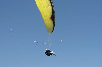
您的问题是可以用来飞伞么!?")
GPS都可以用来飞伞啊!就看你怎么用了!
这是不是传说中的“小犀牛”?好像见人用过,我倒是没用过,不知道现在为什么没人用了!?")
GARMIN公司出品比赛应该承认的吧?用过的出来说说经验啊!
楼主或者利用磨房的“搜索”功能输入“Rino120”就会有部分答案出来了!
用普通电池的对讲机一般都是超业余产品,频段多半和俱乐部对不上.
GPS嘛, 买就买专业点的, 建议看76系列,如有有野心一定买配有气压计的品种.
比赛认证来说,只有一部分中高端Garmin产品,和很少几个其他品牌可以用于滑翔伞比赛,Garmin低端一些产品FAI是不承认的.不过对于中国来说,越野比赛10年8年也遇不到一次,这个功能倒不必担心~~
我用过一年多120,120飞伞可以用,比赛也承认。对讲功能0.5W飞伞够用了(在天上)
从功能上来说不比76差,但屏幕要小些,背部不平不易摆放。
电池爱掉电则是GARMIN不用内置锂电池的GPS的通病,120也不例外。
可以汉化成繁体版。
对讲机功能和其他家用对讲机(就是motorola那些什么6200等)互通不是太好,和贵的那些就没试过。
你们湖南飞伞好像用的就是美国的民用开放频段,用它可以考虑,但出来就不能用了。
GARMIN现在出了款5W的更好。
决无推荐的意思,就是秀一秀
对讲机功率加大了,电池改锂电了,屏幕分辨率也加大了,也彩屏了,也用usb接口了。
Specifications
Radio features Channels: 15 GMRS channels*, 7 FRS channels, 8 GMRS repeater (USA only), 7 NOAA weather channels
TX Power:
FRS = 0.5w
GMRS = 0.5w, 2w, 5w (USA)
0.5w, 2w (CAN)
Squelch codes: 38
Range: Up to 2 miles on FRS channels; Up to 14 miles on GMRS (transmit power limited to 2 watts in Canada for a range of up to 8 miles)
Modes: Channel scan with programmable scan list; channel monitor
Call tones: 10 call and ring tones, 4 roger tones
VOX: External Voice Activation with sensitivity selection
Other features: Alarm, calculator, calendar, clock, lap timer, stopwatch, games
Location reporting features User ID: 10-character name with graphic symbol
Location sending: One button press with Call or Talk button**
Location receiving: Automatic; keep track of up to 50 Rino contacts; allows user to poll other user's position
Contact GoTo: Navigation data automatically updated to contact’s latest location
Contact TracBack®: Lets you retrace the path of up to 20 contacts
Contact Quick View: Lets you quickly center all contact locations on map
Contact Assembly: Lets you and your contacts send and navigate to a common destination
Proximity alarm: Alerts you if contact moves out of a specified distance radius or if you are within a specified distance of a waypoint
Navigation features Waypoints/icons: 500 autoroute waypoints with name, graphic symbol and notes
Routes: 50 reversible
Tracks: 10,000 track points. Automatic track log; 20 saved tracks let you retrace your path in both directions
Trip computer: Current speed, average speed, time of sunrise/sunset, resetable maximum speed, trip timer, trip distance, electronic compass (530 only) and barametric altimeter (530 only)
Tables: Built-in celestial tables for best times to fish and hunt, sun and moon rise/set based on date and location
Map datums: More than 100
Position format: Lat/Lon, UTM/UPS, Maidenhead, MGRS, Loran TDs and other grids, Light Autorouting Basemap included
GPS performance Receiver: WAAS-enabled, 12 parallel channel GPS receiver continuously tracks and uses up to 12 satellites to compute and update your position
Acquisition times:
Warm: Approximately 15 seconds
Cold: Approximately 45 seconds
AutoLocate™: Approximately 5 minutes
Update rate: 1/second, continuous
GPS accuracy:
Position: < 15 meters, 95% typical***
Velocity: 0.05 meter/sec steady state
DGPS (USCG) accuracy:
Position: 3-5 meters, 95% typical
Velocity: 0.05 meter/sec steady state
DGPS (WAAS) accuracy:
Position: < 3 meters, 95% typical***
Velocity: 0.05 meter/sec steady state
Dynamics: 6g’s
Interfaces: USB RS232 serial interface requires optional accessory cable 010-10572-00
Antenna: Quad-helix
Power Source: High capacity 8.4v 2400 mAh Li-Ion Battery Pack
Battery life: 16 hours typical with Li-Ion pack (5W TX power); 18 hours typical with Alkaline battery pack (2W TX power)
Physical Size: 5.1"H x 2.3"W x 1.8"D; 7.5"H with antenna (13 x 5.8 x 4.6 cm; 19 cm with antenna)
Weight: 10.3 ounces (294 g) with Li-Ion battery pack; 6.2 ounces (175g) without battery
Display: 1.7"H x 1.3"W; 176 x 220 pixels, 256-color transflective TFT
Case: Waterproof to IEC 60529 IPX7 standards
Temperature range : -4º to 140º F (-20º to 60º C)
User data storage : Indefinite, no memory battery required
Electronic compass feature (Rino 530 only) Accuracy: ±5 degrees average
Resolution: 1 degree
Barometric altimeter feature (Rino 530 only) Accuracy: 10 feet with proper calibration (user and/or automatic calibration)
Resolution: 1 foot
Range: –2,000 to 30,000 feet
Elevation computer: Current elevation, resettable minimum and maximum elevation, ascent/descent rate, total ascent/descent, average and maximum ascent/descent rate
Pressure: Local pressure (mbar/inches HG), 48-hour automatic pressure trend recording
Specifications are subject to change without notice.
* Using GMRS requires FCC license in the United States. No license is required in Canada.
**Location sending/receiving is available on both FRS and GMRS channels in the US and Canada. The minimum time between updates is 30 seconds (as specified by FCC), except when responding to a polling request
*** Subject to accuracy degradation to 100m 2DRMS under the U.S. Department of Defense Selective Availability Program.
Rino120 GPS我正在用,是雄驴GG无尝给我用的,系统软件已经改写了繁体版,界面不错,电池也挺耐用的,可惜这里用的不普遍,对讲机的频率是固定的,没法调到常用频点,发挥不了对讲机发坐标的功能,这可是他的买点哦!还有就是搜星困难,每次收不到星都要关机再开,有时候要开关两三次才能收到星,开机就自动开对讲机(系统设置没有选择项),发觉收到星前关闭对讲会导至收不到星或收星特别困难,要收到3棵以上以后才能关闭对讲机,可能软件版本问题,装不进简体中文地图。这些问题就看阿丫和叮GG谁能解决了?
雄驴的120本来是有故障的,后来我就把他当实验品搞成了繁体版,地图我不会弄,再说也没有现成的繁体版的中国大陆地图。
下载了据说比较详细的中国地图就是说地区版本不对,装不进去。Rino120TUpdate到处都有,但英文版的Update就好象找不到啊?要不刷回英文版试试,
作为日常休闲瞎飞来说,是个GPS就足够了,不求最好,但求有字。
比赛来说,国内组委会要求不严格,就是120GPS的脑子小了点,只有2000个Track点,楼下那个5xx系列的10000个track点还比较靠谱,就是怕对讲机频率对不上。
其实对讲机要比GPS重要,最好是开频的业余手台,不然万一你凑热闹参加个国内的小赛事,和大会频道对不上就抓瞎了,人家说往东你往西,人家说下雨你往上窜。
这机飞伞就别买啦!我的在几年前就卖拉")
DIY后的 60CSx!!
实在忍不住,又败了台 60CSx!!把自己 DIY的现成中文地图装上!!!
虽然用的还是 101 的地图,但寥胜于无呀!
再说,这价格....嘻嘻....嘻嘻.....让人不败都不好意思了!!!!
看到了吗?现成的繁体版的中国大陆地图。
用 101去年 680MB 的那个地图转的,去了好几个城市,还是很满意的,除了个别新修的路。亲自验证的城市(乌鲁木齐,兰州,西安,大连,大庆,北京,天津,上海,广州,深圳,中山,哈尔滨,郑州,洛阳)
哪里有得下啊?
没得下呀!只有我老人家手头有.....
没有下就算了,总会有办法的