
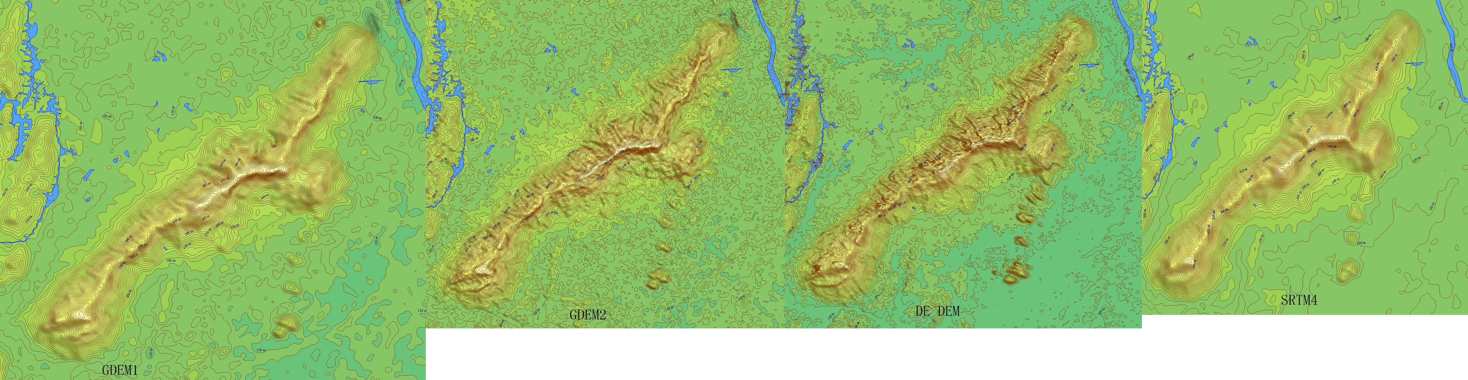
GDEM2的数据山体精度较GDEM1有了提高,水体部分的控制要好于DE DEM,数据有待大家检验,个人认为悬崖的表现要比DE DEM来得可靠一些,其它的大家自己比较一下,发表意见!
用GM生成,10M等高线。
转新浪网链接:美卫星拍最详细3D地图 覆盖地球99%大陆
新浪科技讯 北京时间10月26日消息,这是我们这个世界最完整的数字“地形”图,它以3D的形式显示出山脉和其他地貌特征。这些详细的令人难以置信的地图,利用地面设备并不能获得,这些图是由美国宇航局“大地(Terra)”卫星上的可见光/红外照相机拍摄,然后拼接成地球的高低立位(elevation map)图。目前该图已经覆盖地球大陆的99%。
这张名叫“全球数字高程模型(The Global Digital Elevation Model)”的地形图,是利用“大地”卫星搭载的ASTER(日本先进星载热辐射和反射辐射计)收集到的图片合成的。该仪器是美国宇航局的地球观测系统的组成部分,它利用陆地表面的温度、反射比和海拔“绘制”地面的地形图。该相机从可见光和红外光的范围内拍摄图片。这张地形图是用2D图(即已知的立体像对)制成的“3D”图组成的。它的第一个版本于2009年公布,但是现在它已经新增26万个“立体像对”图。
整张图经过不断修改,清晰度得到很大提高,而且水平和垂直方向的准确度也有所增加,目前已经能够识别出直径仅为1公里的水体。华盛顿美国宇航局总部的科学家伍迪-特纳说:“ASTER全球数字高程模型目前已经是世界上最完善、最可靠的全球地形图。”加利福尼亚州帕萨迪纳美国宇航局喷气推进实验室的ASTER科研组负责人麦克-埃布拉姆说:“它的这个更新版为民用用户提供了最清晰的全球地形数据。”ASTER图覆盖地球大陆块的99%,跨度从北纬83度直到南纬83度。该局发出警告说,图里可能偶尔会出现“一些异常”,但它表示,它希望该数据最终能被应用在道路规划等方面。(孝文)
1) 简介:http://www.nasa.gov/topics/earth/features/aster20111017.html
2) 下载地址:https://wist.echo.nasa.gov/api/ (速度较慢)或者http://www.gdem.aster.ersdac.or.jp/ (可能不好用)
------转自小胖熊
这数据实在是难下载,有时间下载的时候经常登不上服务器,不过现在中国北纬31度以南的数据已全部下载完毕,共361个文件,下载后解压删除num文件再压缩保存,体积约2.55G,下完全中国数据约9-10G左右,可以接受,继续往北推进,下载数据。
数据太大,处理起来很麻烦,还好,这两天下载挺快的,中国北纬37度以南的数据基本下载完了。
回复一个更直观的广东分块图供参考

似乎效果不错啊
ASTER User Notification - October 2011
The Ministry of Economy, Trade, and Industry (METI) of Japan and the United States National Aeronautics and Space Administration (NASA) announced the release of the Version 2 ASTER Global Digital Elevation Model (GDEM) on October 17, 2011. The Version 2 release features improved spatial resolution, increased horizontal and vertical accuracy, and superior water body coverage and detection. Version 2 ASTER GDEM data is available to users free of charge from the Land Processes Distributed Active Archive Center (LPDAAC) or Earth Remote Sensing Data Analysis Center (ERSDAC).
Version 2 of the ASTER GDEM is developed, employing an advanced algorithm to improve GDEM resolution and elevation accuracy and reprocessing a total of 1.5 million scene data including additional 250,000 scenes acquired after the previous release. Accuracy of this latest version is validated by the collaborate effort between Japan and the United States, which shows significant improvements over Version 1 (*3). The ASTER GDEM Version 2 will be formally released as an upgrade to Version 1 on October 17, 2011.
Quality Improvements in Version 2
(Example 1) Enhanced ground resolution: The Northern Alps, Japan
The resolution was greatly improved by the new GDEM generation algorithm, from equivalent to about 120m (Version 1) to 70 m (Version 2).
这问题就来了:到底ASTER的空间分辨率是多少?30m还是70m?
Ver.2 Ver.1
Enhanced ground resolution
(Example 2) Reduction of voids: High-latitude areas
Voids observed at high latitudes in Version 1 are removed significantly in Version 2 after addition of 350,000 new scenes
Ver.2 Ver.1
Reduction of voids (black indicates data void)
(Example 3) Flat lake surface: Lake Nicaragua
Lake surface appears completely flat in Version 2 by the new GDEM generation algorithm.
Ver.2 Ver.1
Flat lake surface
(Example 4) Correction of anomalies: Northeastern part of southern Africa
Anomalies caused due to lack of observation data disappeared after addition of 350,000 new scenes.
哪里可以下载?
同感
好消息,能否提供下网址?谢谢了
同问出处?
谢谢,试用下
Quality Improvements in Version 2
(Example 1) Enhanced ground resolution: The Northern Alps, Japan
The resolution was greatly improved by the new GDEM generation algorithm, from equivalent to about 120m (Version 1) to 70 m (Version 2).
这问题就来了:到底ASTER的空间分辨率是多少?30m还是70m?
再看验证报告中提到:
The Japan study noted that the horizontal displacement in GDEM1 of
0.95 pixels was reduced to 0.23 pixels in GDEM2. Both teams noted improvements in
horizontal resolution, between 71 and 82 meters, comparable to the SRTM 1 arc second
elevation model, but at the cost of some increased noise. The number of voids and
artifacts noted in GDEM1 were substantially reduced in GDEM2
SRTM 1 arc second就是传说中的30m数据,这似乎说明ASTER v2的实际精度远远没有达到30米,只是比SRTM 3“数据略为好一点点,为什么说这个数据和SRTM 30m comparable,我不甚理解
新算法的代价是增加了噪声---数据更毛糙了
不过位置偏移有了明显的进步,减少偏差0.6个像素意味着减少了20米的水平位置偏差,很不错了
报告再提到
The GDEM2 has the same gridding and tile structure as
GDEM1, but benefits from the inclusion of 260,000 additional scenes to improve
coverage, a smaller correlation kernel (5x5 versus 9x9 for GDEM1) yielding higher
spatial resolution, and improved water masking. Also, a negative 5 meter overall bias
observed in the GDEM1 was removed in newer version.
值得注意的是,数据准确性校验除掉日美本土的部分,主要是由NGA用SRTM 1”数据做的比较,很显然SRTM 1“仍然被看作是比ASTER更可靠的数据
SRTM, a radar sensor, also generally mapped the upper surface of land cover, although -
unlike ASTER - it did so exclusively in February during leaf-off conditions for northern
deciduous forests
ASTER如果不在冬季落叶的时候拍照,高度数据就会明显受树木的遮蔽
The GDEM2 is evaluated against DEMs used for both national (Japan, US) and global
applications. As described above, the GSI DEM is the reference used for the Japan study
and the NED and SRTM DTED2 were used in the US study. Globally, the NGA used the
SRTM DTED2. Note that, unlike the GDEM1 validation, the 3 arc-second SRTM DEM
was not used in the CONUS study
ASTER v1的时候还在使用SRTM 3”数据作校验,现在终于舍得用1“的了
GDEM2, like GDEM1 and full-resolution SRTM, has 1-arc-second (approximately 30m)
postings, but none of them have 30m horizontal resolution. Previous studies found that
horizontal resolution for SRTM exceeds 60 meters (Smith and Sandwell, 2003; Guth,
2006). Later, the Japanese and US ASTER Science Teams independently found the
horizontal resolution of GDEM1 to be on the order of 120 meters (Crippen, 2009;
Tachikawa et al., 2009). This was determined by statistical comparisons to much-higher
resolution DEMs for which the horizontal detail was degraded until it best matched that
of GDEM1.
这张表很有趣,他足以证明其实SRTM 3”数据和1“数据的分辨率并不是差3倍,也验证了早先我发现的ASTER v1并不比SRTM 3”数据精度高,ASTER v2终于有所进步!
The US ASTER Science Team has also visually compared GDEM2 to full-resolution
SRTM at numerous sites around the world(中国境内两个区域:山西和西藏) and found their horizontal resolutions to be
very similar in many cases. This can be evident in standard shaded relief or height-asbrightness displays (figure 12), but a simple difference image generated from the two
DEMs can further highlight their relative horizontal resolution differences, if any. In
sharp relief terrain, the poorer resolution DEM will have lower ridges and higher gullies
(but similar slopes) compared to a higher resolution DEM, resulting in a distinct ridge
and gully pattern in the difference image. This pattern was commonly found in
comparisons of GDEM1 to full-resolution SRTM, but it is generally not found in similar
comparisons using GDEM2. Thus we conclude that GDEM2 generally has a horizontal
resolution that is substantially improved from GDEM1 and quite similar to full-resolution
SRTM.
好了,同学们大胆用吧,基本分辨率就是SRTM保密版的水平了
但是,新的短滤波器带来了高频噪声增加
看看这噪声,还是和SRTM不能比阿
同时,NGA的报告也提到,悬崖在ASTER v1中和SRTM 1“ 比V2更吻合
国外的一个动画显示几种数据的差异效果。
虽然有点费劲,总算下了广东部分的GDEMv2数据。
")
我建议楼主开个115的下载,方便大家,数据下载也可以分下工,北方的兄弟搞定北方的,南方的搞定南方的
数据减肥最好的办法是重采样到60m数据,不损失精度且减体积3/4
数据太大,处理起来很麻烦,还好,这两天下载挺快的,中国北纬37度以南的数据基本下载完了。
可否给广东部分?谢谢
数据量大可以考虑用电驴或BT分享。
aster v2,看演示图效果还是明显,下载辛苦,如能共享感谢了
我公司下载速度很快,谁搞个地址,我可以下载!
8楼有连接,网速快的话,帮忙给大家分享一下吧。
谢谢东北老哥给的高程数据
生成等高线地图比较发现相差还是很大,V2更接近实地
我收到邮件,有下载地址.需要的同学可加-QQ1004978056
我的网速太慢了
服务器挂了?几天都上不去了,我从南向北下到北纬42度,有没有有北方数据的,互补一下
日本的服务器经过几天的停机维护,现已重新开放。目前的下载速度比较快。
下载中。
有网址吗。提供个,谢谢!
试下了几块速度很快,想一次下完全中国,竟然只能一次下1000块
那位大侠能共享一下,就功德无量了。