来源:http://www.planetmountain.com/en ... news1.lasso?l=2&;keyid=40261#
作者:Dave Anderson
翻译:zjm424
In China'sShaluli Shan mountain range Dave Anderson and Szu-ting Yi have made the firstascent of Kemailong (5870m).Dave Anderson 与 Szu-ting Yi两人于2012年10月1日首登四川沙鲁里山脉喀麦隆峰(5870米)


原文如下:
An American/Taiwanese expedition spent a month in theremote Shaluli Shan Range of Western Sichuan, China and came away with a firstascent of the striking granite tower Kemailong 19,259ft. On October 1, 2012, DaveAnderson and Szu-ting Yi climbed the 3,500ft south ridge to the summit andrappelled the east face returning to their high camp in an18 hour round trippush. Anderson and Yi named their route Joining Hands (V, 5.10, M5) for theircombined logistical and climbing skills that allowed them to succeed in the Shaluli Shan Mountains
This was American Dave Anderson’s third expedition to the ShaluliShan in the last six years. In October 2006, he and Canadian Sarah Heunikencompleted the first ascent of Sachun 18,753ft, a “Patagonia-like” spire, via“Dang Ba ’Dren Pa” (5.10+ A0 M5 70°). Last year he returnedin September with American Eric Salazar and Taiwanese Szu-ting Yi and climbedthe West Ridge (IV, 5.7, 60°) of the unclimbed peak Crown Mountain18,373ft.
In fall 2012 Anderson and Yi set their sights on climbingKemailong, located several valleys to the north-east of Mt Genyen 20,354ft, thearea’s highest peak. The expedition almost ground to halt in the town of Lamaya when the horse packers discovered Anderson’s and Yi’s climbing equipment. Theproblem did not evolve around permit issues or the peak being consideredsacred, it was about self preservation. In 2006, Charlie Fowler and ChristineBoskoff disappeared in the Shaluli Shan Range.Before the bodies of Fowler and Boskoff were discovered in avalanche debris onthe slopes of Genyen, the Chinese authorities had imprisoned several of theLamaya horse packers merely on the suspicion that they had something to withthe Americans disappearance. As a result, six years later, the horse packerswere still fearful of helping climbers. To resolve the issue, Yi and Andersonwrote, signed and finger printed a “waiver” releasing the horse packers fromany responsibility if they failed to return from Kemailong.
During the approach into the mountains, Anderson was amazed at the changes that hadtaken place to the area in the last six years. New roads and electrical linesnow crisscrossed the remote region which had previously been the domain of onlynomads and their yaks.
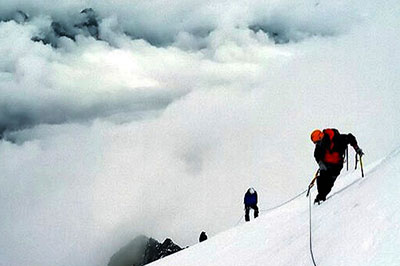
At their base camp below Kemailong, Anderson and Yi werechallenged by poor weather to even see a way up the lower section of the peak.Eventually the clouds parted enough for them to piece together a potentialapproach. Having already spent three weeks above 14,000ft while guiding in thearea prior to the climb allowed Anderson and Yi to quickly navigate up agrueling 3,000 ft long boulder field on south side of Kemailong and establish ahigh camp at 17,060ft.
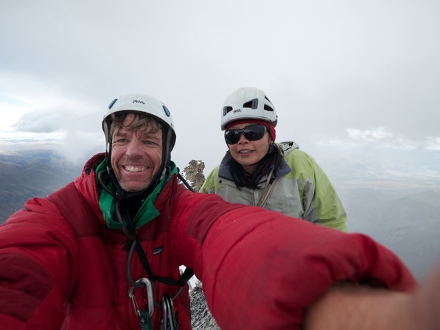
On October 1, a midnight weather check revealed starsinstead of the usual fog and hail. At 7:00 am Anderson and Yi climbed threemixed pitches to gain the saddle on the South ridge of Kemailong.From there thepair ascended moderate fifth class climbing for 900ft up the broad ridge. Asthe ridge narrowed the climbing became more challenging, but the featuredgranite kept difficulty just under 5.10 for the next four pitches. The rockcontinued to improve and the team was able to simul-climb 1,200ft of rockreminiscent of the East Ridgeon Wolfs Head in the Cirque of the Towers. More mixed pitches led to a falsesummit with the true summit being several rope lengths away past a series ofrock gendarmes plastered with snow. The final pitch started with a stoutoverhanging hand crack (5.10) before easing to unprotected face climbing andthe summit.
By thetime Anderson and Yi summited at 5:00pm, the weather had deteriorated. Gustywinds, hail and electrical discharges zapped the climbers as they scrambled toget off the summit. Their original plan was to descend the south ridge, butwith all their metal equipment still humming from the electrical storm,Anderson and Yi decided to quickly bail off the steep, but unknown, 2,300fteast face. The weather continued to worsen with heavy snow compounding thedifficulty of finding crack systems to set up rappel anchors. Finally afterseveral stuck ropes and leaving most of their rack during 13 rappels, Andersonand Yi stumbled back to their high camp at 1:00am. The next morning, with theweather still unstable, they headed down to their base camp, packed up andhiked out of the Shaluli Shan Rangeas the winter season moved in.
“It is aninteresting time to be exploring China’sWestern Mountains,”Andersoncommented. “Presently, the Chinese government is pouring money into Western Sichuan’s infrastructure. Improved roads and newairports have dramatically shortened the approach times.,However, even though the physical logistics of accessing these areashave gotten easier, weaving through the bureaucracy, nationalism, social andcultural diversity of China remains challenging.” The climbers would like to thank Planet Granite,the AAC Lyman Spitzer Cutting Edge Award, Atunas, Patagonia,Evolve and NOLS for making the expedition possible.
by Dave Anderson
原文翻译:
一对美国与台湾登山者组成的组合日前花了一个月时间于2012年10月1日首登四川西部沙鲁里山脉喀麦隆峰.喀麦隆峰属于典型壁花岗岩地质结构的大岩壁,海拔5870米。2012年10月1日DaveAnderson and Szu-ting Yi 花了18个小时沿峰南山脊首登喀麦隆,并由东山脊下撤返回大本营,此条路线高差1000米。为了纪念他们在沙鲁里山脉的攀登及后勤补给的完美结合,Anderson andYi把他们的这条线路称作“携手”(难度级别: 攀岩5.10,冰雪岩混合路线M5)。
这是过去六年中Dave Anderson第三次攀登沙鲁里山脉。在2006年,他与来自加拿大的Sarah Heuniken搭档完成了第一次攀登,这次攀登抵达了一个类似巴塔尼亚的山尖,线路命名为“Dang Ba ’Dren Pa”(难度:5.10+ A0 M5 70°)。去年九月安德森与他的美国同伴Eric Salazar 和中国台湾登山者 Szu-ting Yi重回沙鲁里山区,沿着西山脊攀登了海拔5600米的未登峰—皇冠峰(难度:IV, 5.7, 60°)
在2012年的秋季,安德森跟小易把他们的目标设定在攀登位于沙鲁里山脉最高峰格聂神山东北方向几个山谷的喀麦隆峰上。进山时当村民发现他们的攀登装备后,运输队在喇嘛垭乡停了下来不愿继续前进。村民停下来的理由既不是不允许登山队登山也不是因为认为喀麦隆峰神圣不可侵犯。而是害怕万一登山者出事以后担责任做。因为在早2006年CharlieFowler和ChristineBoskoff两位登山者在攀登四川格聂山时遭遇雪崩遇难,我国有关部门认为当地马帮与美国登山者遇难有关禁止了当地的马帮运输生意。六年后当安德森与小易攀登喀麦隆峰时,马帮因为心存顾虑而不愿意帮助运输装备。为了解决这个问题,小易与安德森签署了免责协议并在上面印了自己的手印,一旦发生任何意外都与当地马帮无关。
在进山的路上,安德森惊讶于地形与六年前比发生了翻天覆地的变化。新的公路与电线在这个偏远地区交错纵横。而六年前这个地方只有牧民和他们赖以为生的牦牛。
在喀麦隆峰大本营,安德森和小易遭遇了坏天气,能见度很低以至于无法观察前进路线。最终乌云散去他们俩得以勉强找到一条攀登路线。在花了三周呆在海拔4000米以上后,小易与安德森经过多次侦查确定并快速完成了一条位于南山脊高差1000米的碎石坡并且最终在5200米设立了C1。
在十月一日的午夜当满天繁星代替往日出现的大雾以及冰雹后, 小易与安德森在7点钟完成三个绳距的攀登到达了喀麦隆峰南山脊的一个鞍部。从那以后这对组合完成了接近300米高差,难度为五级的攀登后他们到达一个暴露感很强的山脊。由于山脊很窄,攀登变得愈发困难。接下来四个绳距的攀登难度始终低于5.10。随着海拔的升高,裸露的岩石变得越来越多,这使得这对组合得以使用上升器完成了接下来370米的攀登。经过多段绳距的交替领攀,他们来到了喀麦隆峰的假顶,然而真正的顶峰任然距离他们任然有几个绳距。在通往顶峰的路上他们发现岩石上有越来越多的积雪。最后一段绳距的攀登始于一个可以放得进手的突出裂缝(难度5.10)这对组合在最后一段通往顶峰的路线上甚至进行了无保护攀登并且最终登顶
安德森与小易在北京时间下午5点成功登顶喀麦隆峰,这时天气开始恶化,阵风,冰雹以及闪电使得这对组合不得不抓紧下撤。他们原先的计划是沿着南山脊下撤。但是由于担心他们所有的技术装备引起雷击,他们选择了改变计划并沿着陡峭的未知的高差为700米的东山脊下撤。天气持续的恶化,大雪降临到了喀麦隆峰上,这使得设立锚点做保护站变得异常的困难。在下撤过程中他们经历了路绳被岩石卡住,丢弃装备等问题后,这对组合经历了13次下降后在第二天临晨1点回到了C1。第二天一早天气任然不见好转。他们立即返回了大本营。并在冬季到来之前撤出了沙鲁里山脉。
“攀登中国西部山区很有意思,”安德森评论道。“目前中国政府正在投资建设西部地区的基础设施,其中包括了修建公路以及兴建机场,这极大的缩短了登山者进山的时间然而,尽管进山时间缩短了后勤,补给方便了,但是如何处理与政府,民族主义,社会以及文化的差异之间关系任然对登山者是一个挑战。
我们一对登山者想要感谢Planet Granite品牌,American Alpine Club对于本次攀登的赞助,台湾Atunas品牌,Patagonia品牌,Evolve品牌以及NOLS是这些公司的赞助才使得喀麦隆峰的攀登得以实现。
——戴夫 安德森
恭喜啊。沙鲁里很多好地方。。。
看了, 翻译不错 !!